Finding buildings - Brazil (1)

Přehled projektů
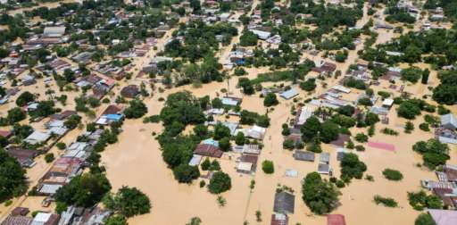
After two weeks of intense rain, gales, and hail in Rio Grande do Sul, Brazil, the collapse of the curtain of the July 14th hydroelectric dam has exacerbated an already critical situation, resulting in more than 100 deaths and 100 missing. More than one million people are affected. Nearly 70,000 have been evacuated and over one million homes are without drinking water. Additionally, 421,000 households lack electricity, and 115 municipalities are without telephone and internet services. There are 61 blocked roads and the Porto Alegre airport remains closed. The Guaíba River has reached record levels, flooding the historic center of Porto Alegre. The current estimated river level is 5.33 meters, and it is expected to exceed 5 meters. This event marks the second significant disaster in less than a year for the state, following a cyclone in September 2023 that left at least 31 dead. Climate change, along with the El Niño phenomenon, has intensified extreme weather conditions in the region. Following the natural hazard disaster, the Open Mapping Hub in Latin America and the Caribbean agreed to launch an activation to support response efforts after conversations with local partners in the region, and as we continue to make connections to identify and prioritize data needs.
Stáhnout data
Souhrnné výsledky
Souhrnné výsledky (s geometrií)
HOT Tasking Manager Geometrie
Střední až vysoká shoda Ano Možná geometrie
Skupiny
Historie
Výsledky
Úlohy
Uživatelé
Oblast zájmu
Naše licence
Tento projekt je součástí komunity OpenStreetMap. Cílem jsou vysoce kvalitní geografická data, která jsou volně přístupná a dostupná všem. Vzájemná licence OSM chrání data před přivlastněním službami, které je nesdílejí zpět do OSM.
MapSwipe je uvolněn pod "liberální" nereciproční licencí (Creative Commons Attribution). Kdykoli budete chtít data použít, nezapomeňte uvést přispěvatele MapSwipe.
