Find -Buildings in Gorgol (4)
Přehled projektů
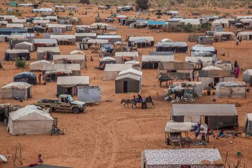
In the HeC region, home to over 471,000 people including 154,000 out-of-camp refugees, many households remain invisible due to extreme population dispersion (3.33 persons/km²). Using MapSwipe, we crowdsource the identification of buildings from satellite imagery, helping to locate isolated homes and villages. This early step enables faster, more targeted mapping, critical for humanitarian response in areas often overlooked due to limited existing data. The region faces growing humanitarian needs: 85% of refugee households are classified as vulnerable, while most lack shelter, sanitation, and access to food and water. Host communities also face severe shortages. MapSwipe helps us detect clusters of population and infrastructure in hard-to-reach areas, supporting equitable planning and ensuring services reach the people who need them most. This work also supports long-term planning. As climate shocks increase and new pressures, such as planned economic zones and refugee camp transformations, emerge, knowing where people live and what they can access is essential. MapSwipe helps lay the foundation for data-informed investments in resilience, infrastructure, and sustainable development
Stáhnout data
Souhrnné výsledky
Souhrnné výsledky (s geometrií)
HOT Tasking Manager Geometrie
Střední až vysoká shoda Ano Možná geometrie
Skupiny
Historie
Výsledky
Úlohy
Uživatelé
Oblast zájmu
Naše licence
Tento projekt je součástí komunity OpenStreetMap. Cílem jsou vysoce kvalitní geografická data, která jsou volně přístupná a dostupná všem. Vzájemná licence OSM chrání data před přivlastněním službami, které je nesdílejí zpět do OSM.
MapSwipe je uvolněn pod "liberální" nereciproční licencí (Creative Commons Attribution). Kdykoli budete chtít data použít, nezapomeňte uvést přispěvatele MapSwipe.