Find Features - Hasiru Aqua Small Pond Mapping - Karnataka, India (1) Open Mapping Hub - AP
Find Features
Finished
Karnataka, India
Open Mapping Hub - AP
Feb 28, 2023
Project overview
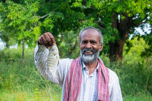
The government of Karnataka has provided subsidies to farmers to build ponds for rainwater harvesting. Many farmers who have built these ponds use it for additional purpose like inland fish farming. Due to being new to fish farming the yield is not good. Having a better yield would mean better economic conditions for these farmers and also better nutrition with the increased protein intake in their diet. Hasiru Aqua is a aquaculture startup helping these farmers by providing them with services like water health monitoring and selling them fish-lings and feeds. They have helped few of these farmers to improve the fish farming yield. In order for Hasiru Aqua to support these farmers they need to know where the ponds are so that they can reach out to farmers in these areas.
4452
km2
456
Contributors
Project Completion
100% completed
Last updated: Oct 13, 2025
Download the data
Below you'll find the data downloads for this MapSwipe project, including a GeoJSON file that can be imported into the HOT Tasking Manager for more detailed mapping of the area. If you need more information or if you have a special request related to MapSwipe data get in contact with the team at the Heidelberg Institute for Geoinformation Technology
Aggregated Results
Aggregated Results. This gives you the unfiltered MapSwipe results aggregated on the task level. This is most suited if you want to apply some custom data processing with the MapSwipe data, e.g. select only specific tasks. Check our documentation for more details. (Note that you need to unzip this .gz file before you can use it.)
GZIP
6.7 MB
Aggregated Results (with Geometry)
Aggregated Results. This gives you the unfiltered MapSwipe results aggregated on the task level. This is most suited if you want to apply some custom data processing with the MapSwipe data, e.g. select only specific tasks. Check our documentation for more details. (Note that you need to unzip this .gz file before you can use it.)
GZIP
6.7 MB
Groups
Groups. (Note that you need to unzip this .gz file before you can use it.)
GZIP
7.9 kB
History
History
CSV
4.5 kB
Results
This gives you the unfiltered MapSwipe results. (Note that you need to unzip this .gz file before you can use it.)
GZIP
3.9 MB
Tasks
Tasks. (Note that you need to unzip this .gz file before you can use it.)
GZIP
5.4 MB
Users
This dataset contains information on the individual contributions per user. This tells you for instance the most active users of this project. (Note that you need to unzip this .gz file before you can use it.)
GZIP
21.9 kB
Area of Interest
This dataset contains information on the project region.
GEOJSON
0.7 kB
HOT Tasking Manager Geometries
This dataset contains shapes that are ready to use in the HOT Tasking Manager. Currently, the geometries consist of maximum 15 MapSwipe Tasks, where at least 35% of all users indicated the presence of a building by classifying as "yes" or "maybe"
GEOJSON
1.1 MB
Moderate to High Agreement Yes Maybe Geometries
This dataset contains all results where at least 35% of users submitted a "yes" or "maybe" classification. The output dataset depicts the union of all selected results.
GEOJSON
2.4 MB
Our license
This project is part of the OpenStreetMap community. The goal is high-quality geographical data, freely accessible and available to everyone. OSM’s reciprocal license protects the data from being appropriated by services that do not share back to OSM.
MapSwipe is released under a "liberal" non-reciprocal license (Creative Commons Attribution). Whenever you want to use the data, just make sure to credit the MapSwipe contributors.
