Find Features - Find Buildings -Mozambique Floods 2026 - Chibuto (2) HOT
Find Features
Active
Chibuto
HOT
Mar 26, 2026
Project overview
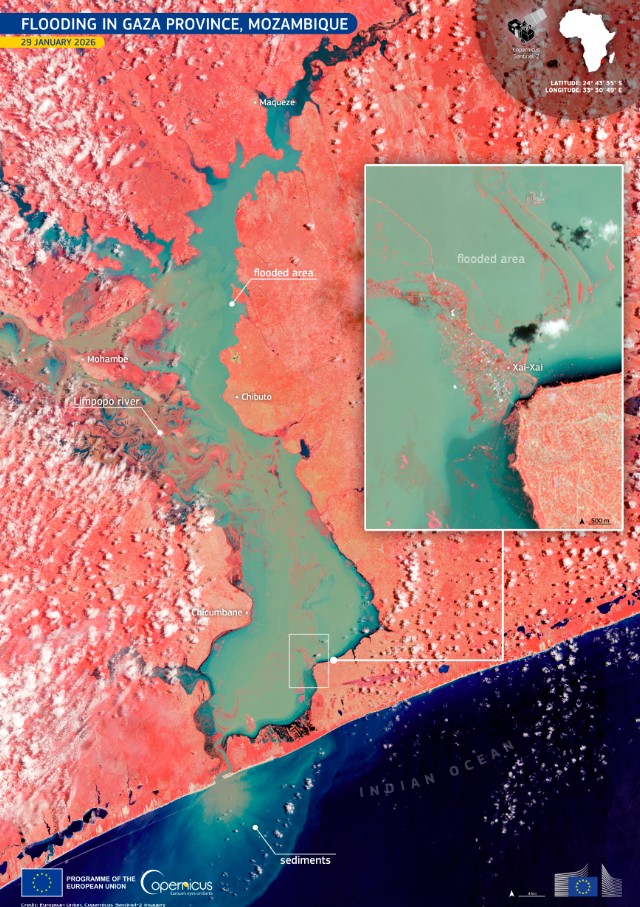
Mozambique is facing one of its most destructive flood emergencies in years. Nearly 800,000 people are affected across the southern and central provinces, especially Gaza, Maputo, and Sofala. Roads, bridges, and health facilities have been severely damaged, cutting off communities and disrupting supply chains. A total of 82,634 houses have been destroyed or damaged, with 123 deaths reported and 101 people injured.
Parts of Maputo were submerged up to rooftop level, and the capital was temporarily cut off from the rest of the country due to flooding on a major highway. The flooding has created dangerous conditions for waterborne diseases and malnutrition, particularly among children. Floodwaters have also pushed crocodiles into urban areas, increasing risks for residents.
Large parts of the affected regions remain unreachable by road, and aid groups report that air and maritime support is urgently needed. The UK has deployed specialist search and rescue teams, including firefighters from West Midlands and Cheshire, to support operations in Maputo Province and Xai-Xai. Aid agencies, including the UN, IFRC, and UNICEF, are coordinating relief efforts and warning of escalating humanitarian needs. ( source: [International Disaster Charter](https://disasterscharter.org/activations/flood-in-mozambique-activation-1015-))
The Open Mapping Hub Eastern & Southern Africa is coordinating with UNICEF, INGD (Mozambique Disaster Risk Management Institute) and OSM Mozambique to provide updated geodata supporting emergency response.
This activation focuses on mapping across affected areas. The updated maps will enable response teams to prioritize relief efforts and coordinate with communities more effectively. See this uMap for the full extent of the Tasking Manager projects and the priority regions.
**We are asking our volunteers to find buildings to support this activation**
More info: [here](https://wiki.openstreetmap.org/wiki/Humanitarian_OSM_Team/Open_Mapping_Hub_Eastern_and_Southern_Africa/Mozambique_Floods_2026)
Picture by [European Union, Copernicus Sentinel-2 ](https://www.copernicus.eu/en/media/image-day-gallery/flooding-gaza-province-mozambique)
701
km2
121
Contributors
Project Completion
62% completed
Last updated: Mar 29, 2026
Download the data
Below you'll find the data downloads for this MapSwipe project, including a GeoJSON file that can be imported into the HOT Tasking Manager for more detailed mapping of the area. If you need more information or if you have a special request related to MapSwipe data get in contact with the team at the Heidelberg Institute for Geoinformation Technology
Aggregated Results
Aggregated Results. This gives you the unfiltered MapSwipe results aggregated on the task level. This is most suited if you want to apply some custom data processing with the MapSwipe data, e.g. select only specific tasks. Check our documentation for more details. (Note that you need to unzip this .gz file before you can use it.)
GZIP
1.1 MB
Aggregated Results (with Geometry)
Aggregated Results. This gives you the unfiltered MapSwipe results aggregated on the task level. This is most suited if you want to apply some custom data processing with the MapSwipe data, e.g. select only specific tasks. Check our documentation for more details. (Note that you need to unzip this .gz file before you can use it.)
GZIP
1.1 MB
Groups
Groups. (Note that you need to unzip this .gz file before you can use it.)
GZIP
3 kB
History
History
CSV
0.6 kB
Results
This gives you the unfiltered MapSwipe results. (Note that you need to unzip this .gz file before you can use it.)
GZIP
1 MB
Tasks
Tasks. (Note that you need to unzip this .gz file before you can use it.)
GZIP
1 MB
Users
This dataset contains information on the individual contributions per user. This tells you for instance the most active users of this project. (Note that you need to unzip this .gz file before you can use it.)
GZIP
6.2 kB
Area of Interest
This dataset contains information on the project region.
GEOJSON
0.7 kB
HOT Tasking Manager Geometries
This dataset contains shapes that are ready to use in the HOT Tasking Manager. Currently, the geometries consist of maximum 15 MapSwipe Tasks, where at least 35% of all users indicated the presence of a building by classifying as "yes" or "maybe"
GEOJSON
0.2 MB
Moderate to High Agreement Yes Maybe Geometries
This dataset contains all results where at least 35% of users submitted a "yes" or "maybe" classification. The output dataset depicts the union of all selected results.
GEOJSON
0.4 MB
Our license
This project is part of the OpenStreetMap community. The goal is high-quality geographical data, freely accessible and available to everyone. OSM’s reciprocal license protects the data from being appropriated by services that do not share back to OSM.
MapSwipe is released under a "liberal" non-reciprocal license (Creative Commons Attribution). Whenever you want to use the data, just make sure to credit the MapSwipe contributors.
