Public Health (6)

Find
Finished
Mangochi District, Malawi
Médecins Sans Frontières
Feb 15, 2023
Public Health (6)

Project overview

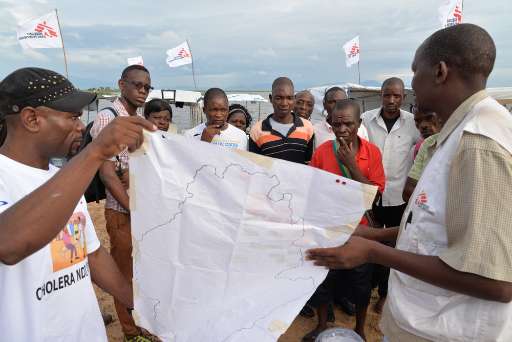
Cholera last broke out in Malawi in 2016. The disease re-appeared in March 2022, primarily affecting districts around Lake Malawi. More than over 11,000 suspected cases have been reported in 29 districts since the disease broke out. At the end of October 2022, Mangochi district experienced a significant peak with a high fatality rate. MSF’s team has set up a 70-bed cholera treatment center in Mangochi district and has also implemented community activities focused on access to clean water and hygiene, as most people living in the area have no other alternative than to drink water taken from the lake. Besides this, MSF is also assisting the Ministry of Health with vaccination in Mangochi district

536
km2
82
Contributors
Project Completion
100% completed
020406080100Mar 04, 23Mar 04, 23Mar 05, 23Mar 05, 23Mar 06, 23Mar 07, 23
Last updated: Jul 26, 2024, 12:10:20 AM

Download the data

Below you'll find the data downloads for this MapSwipe project, including a GeoJSON file that can be imported into the HOT Tasking Manager for more detailed mapping of the area. If you need more information or if you have a special request related to MapSwipe data get in contact with the team at the Heidelberg Institute for Geoinformation Technology
Aggregated Results
Aggregated Results. This gives you the unfiltered MapSwipe results aggregated on the task level. This is most suited if you want to apply some custom data processing with the MapSwipe data, e.g. select only specific tasks. Check our documentation for more details. (Note that you need to unzip this .gz file before you can use it.)
csv
0.9 MB
Download
Aggregated Results (with Geometry)
Aggregated Results. This gives you the unfiltered MapSwipe results aggregated on the task level. This is most suited if you want to apply some custom data processing with the MapSwipe data, e.g. select only specific tasks. Check our documentation for more details. (Note that you need to unzip this .gz file before you can use it.)
geojson
0.8 MB
Download
HOT Tasking Manager Geometries
This dataset contains shapes that are ready to use in the HOT Tasking Manager. Currently, the geometries consist of maximum 15 MapSwipe Tasks, where at least 35% of all users indicated the presence of a building by classifying as "yes" or "maybe"
geojson
0.1 MB
Download
Moderate to High Agreement Yes Maybe Geometries
This dataset contains all results where at least 35% of users submitted a "yes" or "maybe" classification. The output dataset depicts the union of all selected results.
geojson
0.2 MB
Download
Groups
Groups. (Note that you need to unzip this .gz file before you can use it.)
csv
2.1 kB
Download
History
History
geojson
0.5 kB
Download
Results
This gives you the unfiltered MapSwipe results. (Note that you need to unzip this .gz file before you can use it.)
csv
0.5 MB
Download
Tasks
Tasks. (Note that you need to unzip this .gz file before you can use it.)
csv
0.7 MB
Download
Users
This dataset contains information on the individual contributions per user. This tells you for instance the most active users of this project. (Note that you need to unzip this .gz file before you can use it.)
csv
4 kB
Download
Area of Interest
This dataset contains information on the project region.
geojson
62.6 kB
Download

Our license

This project is part of the OpenStreetMap community. The goal is high-quality geographical data, freely accessible and available to everyone. OSM’s reciprocal license protects the data from being appropriated by services that do not share back to OSM.

MapSwipe is released under a "liberal" non-reciprocal license (Creative Commons Attribution). Whenever you want to use the data, just make sure to credit the MapSwipe contributors.