Finding buildings - Brazil (1)

Find
Finished
Rio Grande do Sul
OpenMappingHub - LAC
Jun 6, 2024
Finding buildings - Brazil (1)

Project overview

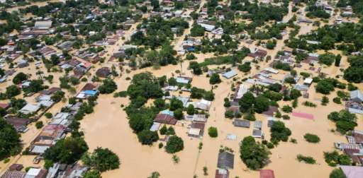
After two weeks of intense rain, gales, and hail in Rio Grande do Sul, Brazil, the collapse of the curtain of the July 14th hydroelectric dam has exacerbated an already critical situation, resulting in more than 100 deaths and 100 missing. More than one million people are affected. Nearly 70,000 have been evacuated and over one million homes are without drinking water. Additionally, 421,000 households lack electricity, and 115 municipalities are without telephone and internet services. There are 61 blocked roads and the Porto Alegre airport remains closed. The Guaíba River has reached record levels, flooding the historic center of Porto Alegre. The current estimated river level is 5.33 meters, and it is expected to exceed 5 meters. This event marks the second significant disaster in less than a year for the state, following a cyclone in September 2023 that left at least 31 dead. Climate change, along with the El Niño phenomenon, has intensified extreme weather conditions in the region. Following the natural hazard disaster, the Open Mapping Hub in Latin America and the Caribbean agreed to launch an activation to support response efforts after conversations with local partners in the region, and as we continue to make connections to identify and prioritize data needs.

229
km2
41
Contributors
Project Completion
100% completed
020406080100Jun 06, 24Jun 06, 24Jun 06, 24Jun 07, 24Jun 07, 24Jun 08, 24
Last updated: Jul 26, 2024, 11:50:24 PM

Download the data

Below you'll find the data downloads for this MapSwipe project, including a GeoJSON file that can be imported into the HOT Tasking Manager for more detailed mapping of the area. If you need more information or if you have a special request related to MapSwipe data get in contact with the team at the Heidelberg Institute for Geoinformation Technology
Aggregated Results
Aggregated Results. This gives you the unfiltered MapSwipe results aggregated on the task level. This is most suited if you want to apply some custom data processing with the MapSwipe data, e.g. select only specific tasks. Check our documentation for more details. (Note that you need to unzip this .gz file before you can use it.)
csv
0.1 MB
Download
Aggregated Results (with Geometry)
Aggregated Results. This gives you the unfiltered MapSwipe results aggregated on the task level. This is most suited if you want to apply some custom data processing with the MapSwipe data, e.g. select only specific tasks. Check our documentation for more details. (Note that you need to unzip this .gz file before you can use it.)
geojson
0.1 MB
Download
HOT Tasking Manager Geometries
This dataset contains shapes that are ready to use in the HOT Tasking Manager. Currently, the geometries consist of maximum 15 MapSwipe Tasks, where at least 35% of all users indicated the presence of a building by classifying as "yes" or "maybe"
geojson
22.2 kB
Download
Moderate to High Agreement Yes Maybe Geometries
This dataset contains all results where at least 35% of users submitted a "yes" or "maybe" classification. The output dataset depicts the union of all selected results.
geojson
37.9 kB
Download
Groups
Groups. (Note that you need to unzip this .gz file before you can use it.)
csv
0.7 kB
Download
History
History
geojson
0.4 kB
Download
Results
This gives you the unfiltered MapSwipe results. (Note that you need to unzip this .gz file before you can use it.)
csv
0.1 MB
Download
Tasks
Tasks. (Note that you need to unzip this .gz file before you can use it.)
csv
96.4 kB
Download
Users
This dataset contains information on the individual contributions per user. This tells you for instance the most active users of this project. (Note that you need to unzip this .gz file before you can use it.)
csv
2 kB
Download
Area of Interest
This dataset contains information on the project region.
geojson
25.3 kB
Download

Our license

This project is part of the OpenStreetMap community. The goal is high-quality geographical data, freely accessible and available to everyone. OSM’s reciprocal license protects the data from being appropriated by services that do not share back to OSM.

MapSwipe is released under a "liberal" non-reciprocal license (Creative Commons Attribution). Whenever you want to use the data, just make sure to credit the MapSwipe contributors.