Finding Buildings in Torbay (1)

Find
Finished
Avalon Peninsula, Newfoundland, Canada
Canadian Red Cross
Jul 4, 2024
Finding Buildings in Torbay (1)

Project overview

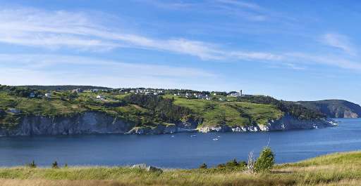
Torbay is a small town of ~7,900 inhabitants located on the Avalon peninsula of Newfoundland, part of the province of Newfoundland and Labrador on Canada's East coast. This coastal location, while beautiful, means that residents are frequently subject to severe weather, including strong blizzards, dense maritime fog, and increasingly powerful hurricanes. Your work on this smaller project will help the Canadian Red Cross identify where buildings are located within the municipal boundaries of Torbay, and improve preparedness for these emergency events. Please focus on identifying buildings exclusively.

37
km2
24
Contributors
Project Completion
100% completed
020406080100Jul 04, 24Jul 04, 24Jul 04, 24Jul 04, 24Jul 04, 24Jul 05, 24
Last updated: Oct 23, 2024, 12:02:39 AM

Download the data

Below you'll find the data downloads for this MapSwipe project, including a GeoJSON file that can be imported into the HOT Tasking Manager for more detailed mapping of the area. If you need more information or if you have a special request related to MapSwipe data get in contact with the team at the Heidelberg Institute for Geoinformation Technology
Aggregated Results
Aggregated Results. This gives you the unfiltered MapSwipe results aggregated on the task level. This is most suited if you want to apply some custom data processing with the MapSwipe data, e.g. select only specific tasks. Check our documentation for more details. (Note that you need to unzip this .gz file before you can use it.)
csv
10.8 kB
Download
Aggregated Results (with Geometry)
Aggregated Results. This gives you the unfiltered MapSwipe results aggregated on the task level. This is most suited if you want to apply some custom data processing with the MapSwipe data, e.g. select only specific tasks. Check our documentation for more details. (Note that you need to unzip this .gz file before you can use it.)
geojson
12.2 kB
Download
HOT Tasking Manager Geometries
This dataset contains shapes that are ready to use in the HOT Tasking Manager. Currently, the geometries consist of maximum 15 MapSwipe Tasks, where at least 35% of all users indicated the presence of a building by classifying as "yes" or "maybe"
geojson
5.1 kB
Download
Moderate to High Agreement Yes Maybe Geometries
This dataset contains all results where at least 35% of users submitted a "yes" or "maybe" classification. The output dataset depicts the union of all selected results.
geojson
6.2 kB
Download
Groups
Groups. (Note that you need to unzip this .gz file before you can use it.)
csv
0.3 kB
Download
History
History
geojson
0.4 kB
Download
Results
This gives you the unfiltered MapSwipe results. (Note that you need to unzip this .gz file before you can use it.)
csv
21.9 kB
Download
Tasks
Tasks. (Note that you need to unzip this .gz file before you can use it.)
csv
8.3 kB
Download
Users
This dataset contains information on the individual contributions per user. This tells you for instance the most active users of this project. (Note that you need to unzip this .gz file before you can use it.)
csv
1.3 kB
Download
Area of Interest
This dataset contains information on the project region.
geojson
0.1 MB
Download

Our license

This project is part of the OpenStreetMap community. The goal is high-quality geographical data, freely accessible and available to everyone. OSM’s reciprocal license protects the data from being appropriated by services that do not share back to OSM.

MapSwipe is released under a "liberal" non-reciprocal license (Creative Commons Attribution). Whenever you want to use the data, just make sure to credit the MapSwipe contributors.