Find - Buildings in Kudat Town, Sabah (1)

Find
Finished
Malaysia
Open Mapping Hub - AP
Nov 19, 2024
Find - Buildings in Kudat Town, Sabah (1)

Project overview

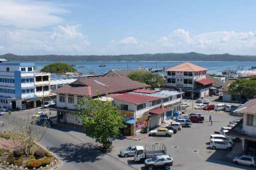
Kudat Town, located along Sabah's northern coast, is on the frontlines of climate change. The town faces growing threats from rising sea levels, coastal erosion, and extreme weather events, which put its communities and ecosystems at risk. Accurate and detailed mapping is essential for understanding these vulnerabilities and supporting climate action. This project leverages the power of community mapping to identify building footprints in Kudat using MapSwipe. By utilizing this user-friendly tool, volunteers can quickly and efficiently identify areas with buildings, providing a solid foundation for more detailed mapping efforts. Once the initial mapping is complete, buildings within the identified areas will be traced using the HOT Tasking Manager to improve data for climate resilience planning. The collected data will aid in disaster risk reduction, adaptive infrastructure design, and sustainable coastal management, empowering local communities to better prepare for and respond to climate challenges.

691
km2
80
Contributors
Project Completion
100% completed
Not enough data points for the chart!
Last updated: Jan 17, 2025, 12:04:40 AM

Download the data

Below you'll find the data downloads for this MapSwipe project, including a GeoJSON file that can be imported into the HOT Tasking Manager for more detailed mapping of the area. If you need more information or if you have a special request related to MapSwipe data get in contact with the team at the Heidelberg Institute for Geoinformation Technology
Aggregated Results
Aggregated Results. This gives you the unfiltered MapSwipe results aggregated on the task level. This is most suited if you want to apply some custom data processing with the MapSwipe data, e.g. select only specific tasks. Check our documentation for more details. (Note that you need to unzip this .gz file before you can use it.)
csv
0.9 MB
Download
Aggregated Results (with Geometry)
Aggregated Results. This gives you the unfiltered MapSwipe results aggregated on the task level. This is most suited if you want to apply some custom data processing with the MapSwipe data, e.g. select only specific tasks. Check our documentation for more details. (Note that you need to unzip this .gz file before you can use it.)
geojson
1 MB
Download
HOT Tasking Manager Geometries
This dataset contains shapes that are ready to use in the HOT Tasking Manager. Currently, the geometries consist of maximum 15 MapSwipe Tasks, where at least 35% of all users indicated the presence of a building by classifying as "yes" or "maybe"
geojson
0.3 MB
Download
Moderate to High Agreement Yes Maybe Geometries
This dataset contains all results where at least 35% of users submitted a "yes" or "maybe" classification. The output dataset depicts the union of all selected results.
geojson
0.5 MB
Download
Groups
Groups. (Note that you need to unzip this .gz file before you can use it.)
csv
2.3 kB
Download
History
History
geojson
0.3 kB
Download
Results
This gives you the unfiltered MapSwipe results. (Note that you need to unzip this .gz file before you can use it.)
csv
0.6 MB
Download
Tasks
Tasks. (Note that you need to unzip this .gz file before you can use it.)
csv
0.8 MB
Download
Users
This dataset contains information on the individual contributions per user. This tells you for instance the most active users of this project. (Note that you need to unzip this .gz file before you can use it.)
csv
4.1 kB
Download
Area of Interest
This dataset contains information on the project region.
geojson
55.5 kB
Download

Our license

This project is part of the OpenStreetMap community. The goal is high-quality geographical data, freely accessible and available to everyone. OSM’s reciprocal license protects the data from being appropriated by services that do not share back to OSM.

MapSwipe is released under a "liberal" non-reciprocal license (Creative Commons Attribution). Whenever you want to use the data, just make sure to credit the MapSwipe contributors.