Land Cover Identification (1)
Project overview
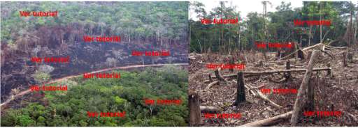
To contribute to this project, first watch the tutorial This project aims to identify changes occurring in the natural ecosystems of the state of Michoacán, Mexico. Help us detect areas where natural vegetation has disappeared through the observation of satellite images. Your participation contributes to building maps that help design actions for ecosystem restoration, conservation, and sustainable management.
Download the data
Aggregated Results
Aggregated Results (with Geometry)
HOT Tasking Manager Geometries
Moderate to High Agreement Yes Maybe Geometries
Groups
History
Results
Tasks
Users
Area of Interest
Our license
This project is part of the OpenStreetMap community. The goal is high-quality geographical data, freely accessible and available to everyone. OSM’s reciprocal license protects the data from being appropriated by services that do not share back to OSM.
MapSwipe is released under a "liberal" non-reciprocal license (Creative Commons Attribution). Whenever you want to use the data, just make sure to credit the MapSwipe contributors.