Find Features - Find - Buildings in Gorgol - Mauritania (4) HOT
Find Features
Finished
Buildings in Gorgol - Mauritania
HOT
Jun 2, 2025
Project overview
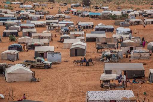
In the HeC region, home to over 471,000 people including 154,000 out-of-camp refugees, many households remain invisible due to extreme population dispersion (3.33 persons/km²). Using MapSwipe, we crowdsource the identification of buildings from satellite imagery, helping to locate isolated homes and villages. This early step enables faster, more targeted mapping, critical for humanitarian response in areas often overlooked due to limited existing data.
The region faces growing humanitarian needs: 85% of refugee households are classified as vulnerable, while most lack shelter, sanitation, and access to food and water. Host communities also face severe shortages. MapSwipe helps us detect clusters of population and infrastructure in hard-to-reach areas, supporting equitable planning and ensuring services reach the people who need them most.
This work also supports long-term planning. As climate shocks increase and new pressures, such as planned economic zones and refugee camp transformations, emerge, knowing where people live and what they can access is essential. MapSwipe helps lay the foundation for data-informed investments in resilience, infrastructure, and sustainable development
3836
km2
0
Contributors
Project Completion
0% completed
Download the data
Below you'll find the data downloads for this MapSwipe project, including a GeoJSON file that can be imported into the HOT Tasking Manager for more detailed mapping of the area. If you need more information or if you have a special request related to MapSwipe data get in contact with the team at the Heidelberg Institute for Geoinformation Technology
Area of Interest
This dataset contains information on the project region.
GEOJSON
0.7 kB
Our license
This project is part of the OpenStreetMap community. The goal is high-quality geographical data, freely accessible and available to everyone. OSM’s reciprocal license protects the data from being appropriated by services that do not share back to OSM.
MapSwipe is released under a "liberal" non-reciprocal license (Creative Commons Attribution). Whenever you want to use the data, just make sure to credit the MapSwipe contributors.
