Find - Buildings in the rural areas (1)
Project overview
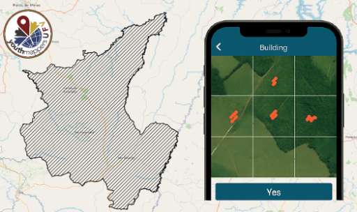
Este projeto tem como objetivo identificar áreas com edificações nos municípios de Rio Paranaíba, São Gotardo, Carmo do Paranaíba, Matutina e Arapuá, localizados na região do Alto Paranaíba, em Minas Gerais. Através da análise colaborativa de imagens de satélite, os voluntários ajudarão a localizar construções e áreas ocupadas, apoiando futuras ações de planejamento urbano, gestão de risco, mapeamento humanitário e atualização de dados no OpenStreetMap. A contribuição de cada pessoa ajuda a construir mapas mais completos e confiáveis dessas cidades, especialmente em áreas onde há pouca informação disponível. Nenhuma experiência prévia é necessária — basta seguir o tutorial dentro do aplicativo e começar a identificar! ## English This project aims to identify areas with buildings in the municipalities of Rio Paranaíba, São Gotardo, Carmo do Paranaíba, Matutina, and Arapuá, located in the Alto Paranaíba region of Minas Gerais. Through collaborative analysis of satellite images, volunteers will help locate buildings and occupied areas, supporting future urban planning, risk management, humanitarian mapping, and data updates on OpenStreetMap. Each person's contribution helps to build more complete and reliable maps of these cities, especially in areas where little information is available. No previous experience is necessary — just follow the tutorial within the app and start identifying!
Download the data
Aggregated Results
Aggregated Results (with Geometry)
HOT Tasking Manager Geometries
Moderate to High Agreement Yes Maybe Geometries
Groups
History
Results
Tasks
Users
Area of Interest
Our license
This project is part of the OpenStreetMap community. The goal is high-quality geographical data, freely accessible and available to everyone. OSM’s reciprocal license protects the data from being appropriated by services that do not share back to OSM.
MapSwipe is released under a "liberal" non-reciprocal license (Creative Commons Attribution). Whenever you want to use the data, just make sure to credit the MapSwipe contributors.