Find Features - Forest intervened and buildings - Colombia dpto de Caquetá - Solano (1) OpenMappingHub - LAC
Find Features
Finished
Colombia dpto de Caquetá - Solano
OpenMappingHub - LAC
Jun 25, 2024
Project overview
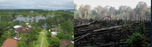
Mapping in the Amazon takes on great importance when considering the vulnerability of the population and the imperative need to preserve its valuable natural resources. This region is home to communities exposed to various hazards, and detailed mapping provides essential information for planning mitigation and emergency response strategies. In addition, the Amazon, as a treasure trove of biodiversity, plays a crucial role in global climate stability. Accurate mapping facilitates the identification of critical areas, contributing to the implementation of adaptation, protection and sustainable planning measures to ensure the long-term survival of the region and its people.
4592
km2
0
Contributors
Project Completion
0% completed
Download the data
Below you'll find the data downloads for this MapSwipe project, including a GeoJSON file that can be imported into the HOT Tasking Manager for more detailed mapping of the area. If you need more information or if you have a special request related to MapSwipe data get in contact with the team at the Heidelberg Institute for Geoinformation Technology
Area of Interest
This dataset contains information on the project region.
GEOJSON
0.7 kB
Our license
This project is part of the OpenStreetMap community. The goal is high-quality geographical data, freely accessible and available to everyone. OSM’s reciprocal license protects the data from being appropriated by services that do not share back to OSM.
MapSwipe is released under a "liberal" non-reciprocal license (Creative Commons Attribution). Whenever you want to use the data, just make sure to credit the MapSwipe contributors.
